


WASHINGTON, Knox County, Indiana
About
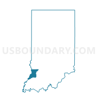
Outline

Summary
| Unique Area Identifier | 578185 |
| Name | WASHINGTON |
| County | Knox County |
| State | Indiana |
| Area (square miles) | 48.84 |
| Land Area (square miles) | 48.59 |
| Water Area (square miles) | 0.24 |
| % of Land Area | 99.51 |
| % of Water Area | 0.49 |
| Latitude of the Internal Point | 38.76738790 |
| Longtitude of the Internal Point | -87.40524840 |
Maps


Graphs
Select a template below for downloading or customizing gragh for WASHINGTON, Knox County, Indiana


Neighbors
Neighoring Voting District (by Name) Neighboring Voting District on the Map
- ALLISON 1 Voting District, Lawrence County, IL
- BICKNELL 3, Knox County, IN
- BICKNELL 4, Knox County, IN
- BUSSERON, Knox County, IN
- PALMYRA, Knox County, IN
- RUSSELL 27 Voting District, Lawrence County, IL
- STEEN, Knox County, IN
- VIGO 3, Knox County, IN
- VINCENNES TWP. 1, Knox County, IN
- VINCENNES TWP. 2, Knox County, IN
- WIDNER, Knox County, IN
Top 10 Neighboring County Subdivision (by Population) Neighboring County Subdivision on the Map
- Vincennes township, Knox County, IN (23,707)
- Vigo township, Knox County, IN (4,031)
- Washington township, Knox County, IN (2,286)
- Palmyra township, Knox County, IN (1,466)
- Busseron township, Knox County, IN (1,393)
- Widner township, Knox County, IN (1,132)
- Steen township, Knox County, IN (900)
- Russell township, Lawrence County, IL (450)
- Allison township, Lawrence County, IL (267)
Top 10 Neighboring Place (by Population) Neighboring Place on the Map
Top 10 Neighboring Unified School District (by Population) Neighboring Unified School District on the Map
- Vincennes Community School Corporation, IN (23,393)
- North Knox School Corporation, IN (8,842)
- Lawrence County Community Unit District 20, IL (8,313)
- South Knox School Corporation, IN (6,205)
Top 10 Neighboring State Legislative District Lower Chamber (by Population) Neighboring State Legislative District Lower Chamber on the Map
- State House District 109, IL (103,405)
- State House District 64, IN (60,833)
- State House District 45, IN (59,062)
Top 10 Neighboring State Legislative District Upper Chamber (by Population) Neighboring State Legislative District Upper Chamber on the Map
- State Senate District 55, IL (213,429)
- State Senate District 39, IN (126,383)
- State Senate District 48, IN (121,761)
Top 10 Neighboring 111th Congressional District (by Population) Neighboring 111th Congressional District on the Map
Top 10 Neighboring Census Tract (by Population) Neighboring Census Tract on the Map
- Census Tract 9552, Knox County, IN (5,973)
- Census Tract 9558, Knox County, IN (3,453)
- Census Tract 8807, Lawrence County, IL (3,119)
- Census Tract 9550, Knox County, IN (3,040)
- Census Tract 9551, Knox County, IN (2,926)